
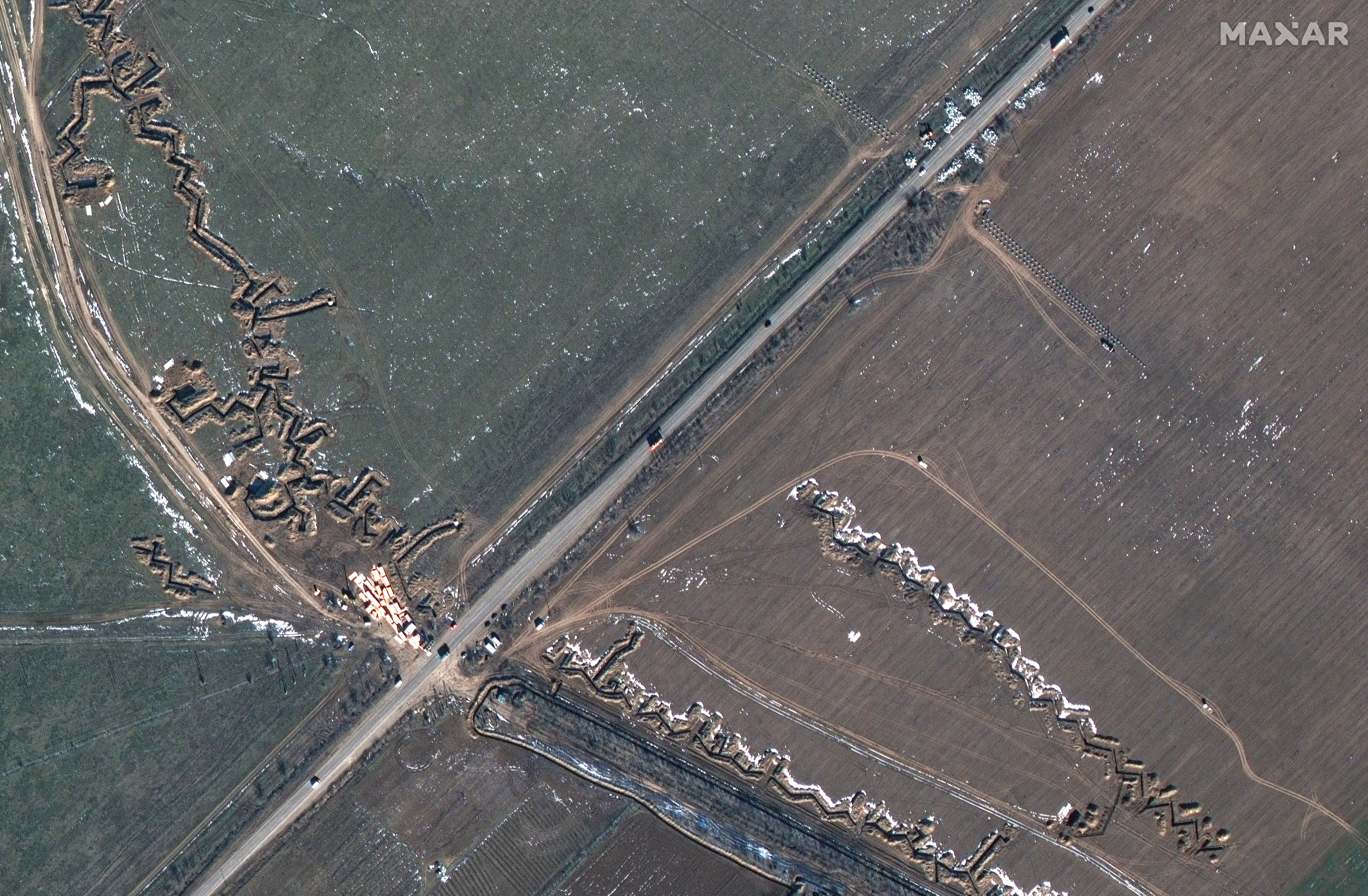
ST. LOUIS — As Russia massed materiel on its border with Ukraine ahead of its invasion in February 2022, commercial satellites orbited overhead.
The images and other readings gathered from afar were critical to grasping the situation in Eastern Europe at the time, and their continued dissemination, including through the press, aids public understanding of the war.
Among those involved in the capture and distribution of such information is Maxar Technologies, which provides satellite imagery to the Defense Department and intelligence community, among other national security pursuits.
In February 2023, for example, the Colorado-based company won an additional round of work on the U.S. Army’s One World Terrain, which compiles extremely accurate virtual maps of territory across the globe for military purposes. It’s considered a key piece of the service’s Synthetic Training Environment, an immersive training-and-rehearsal tool. The company is also involved with Project Maven, launched by the Pentagon in 2017 to detect targets of interest in footage captured by uncrewed systems.
C4ISRNET reporters interviewed two Maxar executives — Tony Frazier, executive vice president and general manager of public sector earth intelligence, and Jennifer Krischer, vice president and general manager of intelligence programs — on the sidelines of the GEOINT Symposium in St. Louis.
Portions of the interview below, conducted May 23, have been edited for length and clarity.
Q: Where do you see the future of One World Terrain and, by extension, the Synthetic Training Environment going? What does that look like?
Frazier: We started with a focus of helping the Army modernize its training with geospecific data, with a goal of being able to provide soldiers as realistic an experience as possible.
Lt. Gen. Maria Gervais, she was the first cross-functional team lead for the Synthetic Training Environment. Her vision at the time was: If we can have reps and sets with hundreds of experiences in the virtual environment, then we can help soldiers be safe when they actually deploy.
That has continued to be the core focus of the program. That being said, as we exposed the data to different parts of the community, there was insatiable demand from the operational users to apply it to current missions. Whether it was in support of the Afghan drawdown, there was data that we provided over Ukraine — using it for operational mission-planning was very prominent.

Even the fiscal 2023 National Defense Authorization Act, there was a reference to One World Terrain, and I think it did a nice job of highlighting the variety of use cases that had been proven out.
So what we’re seeing is, as we build out more complete, global coverage of that capability, being able to use it as a reference layer to integrate other data sources against it, and have all those data sources inherit the same accuracy, that foundation really enables a form of sensor fusion that we haven’t been able to see at scale.
One example that we are demonstrating is how we can apply 3D geo-registration software that uses that reference as a way to take — whether it’s space-based, or airborne, or even an unmanned surface vehicle — a sensor feed and use the terrain as a source of registration to tie that down, both in terms of the right location and the right orientation, so that you’re able to inherit the same accuracy as that base.
Think about a realtime feed from a drone. That would then allow you to be able to know exactly within this type of radius where that pixel is. That, I think, is probably one of the more breakthrough opportunities, in terms of taking it fully operational.
Q: How has the conflict in Ukraine shaped or factored into Maxar’s business? What is that consumption like — is there an increased need for satellite imagery or your other products?
Frazier: We support a global mission, and we’ve been providing these capabilities for decades. And you can look at every major event, and Maxar has played a role in that, in some capacity.
I think what’s unique about Ukraine was that at all phases, the crisis leading to conflict, we were able to, through different channels, expose our capability in a way that was helpful to the mission.
The focus of the Defense Department now is integrated deterrence — the role that commercial was able to play to bring transparency to what was happening, with troop buildup and, as it pivoted to conflict, what was happening on the ground.
The combination of what was exposed through the media, through our partnerships there, along with the fact that the intelligence community, Defense Department, allies and partners were all able to access current imagery over those areas, just allowed a level of interoperability and mission planning that, I think, has helped support the mission, but also helped a lot of decision makers think through ways that can be applied, more broadly.
RELATED
I know you recently covered the Global Information Dominance Experiments series.
One of the things that’s helped us do is have conversations with different stakeholders across the community, who have been looking at how do I take the increased commercial collection, some of the innovation that’s happening with applied machine learning, so computer vision, to be able to interpret imagery quickly, the types of technology I referenced earlier with our 3D, where we can georeference that data on quick timelines, and then how can that support different forms of experimentation. That is demonstrating how new use cases for how commercial can be applied to the here-and-now missions.
We’ve supported Project Convergence and Scarlet Dragon; those were examples of exercises and experimentation that we supported with commercial capabilities. I think we’re seeing that there’s a lot of interest.
Q: The big news at GEOINT yesterday was Project Maven, with Vice Adm. Frank Whitworth talking about its transition to a program of record. How do you envision Maxar taking part in Project Maven, and what do you hope to contribute?
Krischer: We’re already contributing to Project Maven.
We are generating algorithms around both electro-optical and our synthetic aperture radar imaging capabilities. So object detection, using those different modalities.
We also have been working with Project Maven for years now on providing low-latency imagery so that we can run the algorithms against the imagery in a sensor-to-shooter methodology that really resonates with the warfighter. So we’ve already been doing these things.
We envision the future of Maven as being: How do you bring the vast computer-vision algorithms sets to bear on the different missions, whether it be the intel analyst or the warfighter in the field, and how do you enable the warfighter to do these things?
We’re working kind of hand-in-hand to understand what it needs to be and helping shape the future, so that it’s not vendor-locked, it’s really meeting the users where they need the information.
Frazier: In our conversations, the intent is to enable geospatial AI at scale. And, as a result, as these capabilities get more mature, you want to be able to take advantage of all the collection that’s happening across the constellation.
For the U.S. government, the constellation includes commercial as a part of that. That’s why EOCL is electro-optical commercial layer. With the contracts that were awarded to us, and Planet and BlackSky, and then what’s being done now to add other modalities, like radar and radio-frequency sensing and the like, the goal is to create an architecture where you can quickly run the algorithms against that source to then get the information out to those users.
RELATED
We’ve had a lot of use of our existing systems to apply computer vision against the imagery that we’re hosting and disseminating now, across the community, and now it’s about how do we actually do this at scale, have more machine-to-machine exploitation at scale. The last couple of decades have been focused on how humans visualize imagery.
Q: With Project Maven, and with a lot of these things like Joint All-Domain Command and Control, there’s just an incredible amount of collection and data that has to be sorted through. So you can’t ignore the AI or ML portion on your side, right? That has to be baked in, basically?
Krischer: Absolutely.
Frazier: Correct.
Q: Is there a need for a One Space Terrain? Maybe with a more artful name?
Frazier: I can see that happening.
You heard the director of the National Geospatial-Intelligence Agency, his comments, about how they’re supporting the lunar mission. And I think, yeah, we need to have an accurate representation of all domains, where we expect to safely navigate, to be able to mitigate threats, et cetera.
Colin Demarest was a reporter at C4ISRNET, where he covered military networks, cyber and IT. Colin had previously covered the Department of Energy and its National Nuclear Security Administration — namely Cold War cleanup and nuclear weapons development — for a daily newspaper in South Carolina. Colin is also an award-winning photographer.
Courtney Albon is C4ISRNET’s space and emerging technology reporter. She has covered the U.S. military since 2012, with a focus on the Air Force and Space Force. She has reported on some of the Defense Department’s most significant acquisition, budget and policy challenges.


